15 Virginia Scenic Drives Locals Keep Repeating No Matter The Month
Virginia taught me how to drive without hurrying.
I’ve followed two-lane curves where the light keeps changing faster than the scenery, cresting hills that open into sudden valleys and towns where someone still lifts a hand as you pass.
The routes feel old without feeling tired: fog sliding off rivers at dawn, orchards leaning into the shoulder, a gas station hand-breading chicken that makes you pull over without thinking.
I’ve driven the same stretch in three different months and sworn it was three different places each time. Wildflowers give way to mist, gold leaves to clean, bare ridgelines.
These are roads that quiet your voice and sharpen your eyes.
If you’re ready for that kind of driving, all that’s left is to choose a direction.
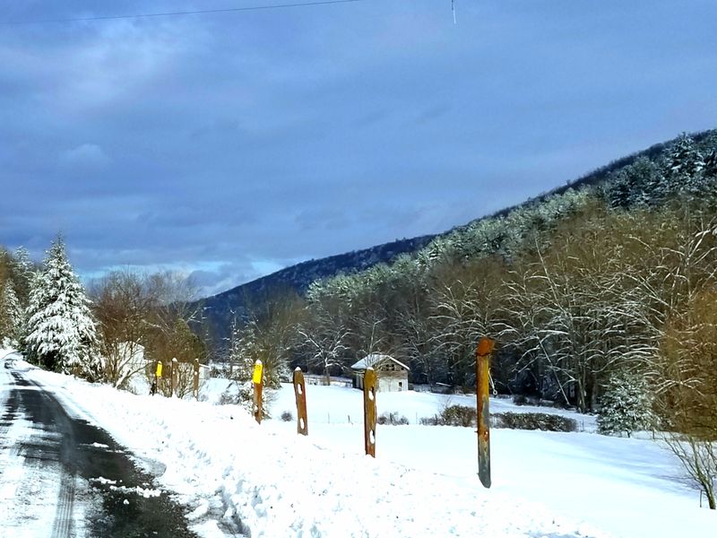
1. Skyline Drive, Shenandoah National Park
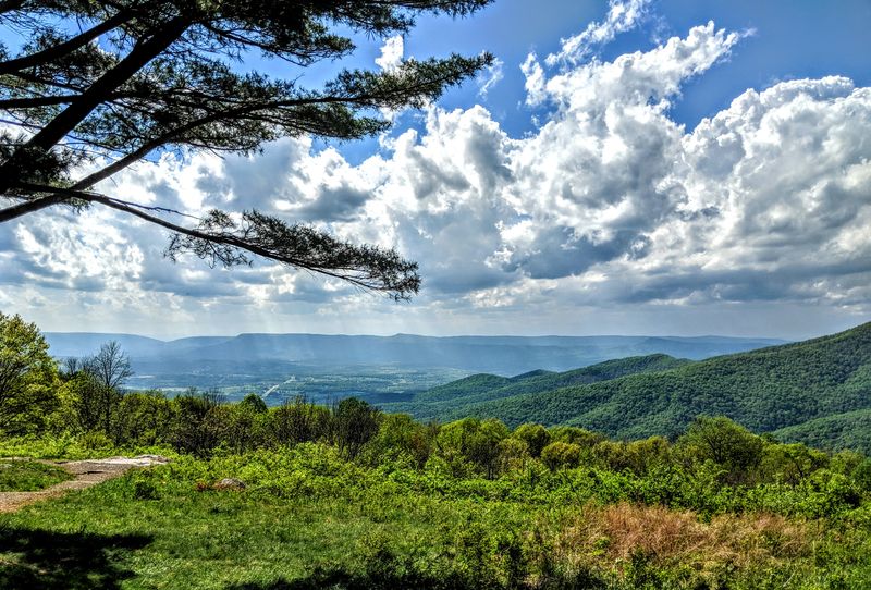
Morning mist drifts over Big Meadows as the Blue Ridge folds into soft layers of pale blue and green.
Skyline Drive was built in the 1930s by the Civilian Conservation Corps and begins near 3655 US-211 East, Luray, VA 22835.
The 105-mile route holds its pace at 35 mph, allowing birdsong and wind to slip through open windows.
Fog can appear suddenly, turning nearby overlooks into quiet stages for watching the valley shift in and out of view.
Stone guardwalls and hand-placed viewpoints create a rhythm that encourages drivers to slow down naturally.
A short walk onto the Appalachian Trail can make returning to the car feel like reentering a different moment.
Even ten minutes on foot expands the sense of distance more than the map suggests.
2. Blue Ridge Parkway, Virginia Mountain Section
Rhododendron tunnels filter the light so gently that even the sound of the engine feels softened.
This Virginia stretch passes Peaks of Otter and Mabry Mill, with a visitor stop at 85554 Blue Ridge Pkwy, Bedford, VA 24523.
Long ridgelines appear like shifting waves, shaped by both early conservation work and Depression-era craftsmanship.
Winter closures after freeze-thaw cycles can send travelers onto detours, so checking conditions becomes part of the ritual.
Picnics feel especially satisfying in the meadows near Rocky Knob, where the horizon looks stitched from muted blues.
Pastures bordered by split-rail fences create a sense of stepping into an old photograph.
Every bend seems to offer a new version of the same mountains, each one a little different from the last.
3. Colonial Parkway Between Jamestown, Williamsburg, And Yorktown
Tabby-colored pavement and brick-faced bridges set a contemplative tone even before the York River comes into view.
The Parkway connects Jamestown and Yorktown with access near 1000 Colonial Pkwy, Yorktown, VA 23690, and was designed to blend seamlessly with its Tidewater surroundings.
The absence of billboards and stoplights makes the route feel like a continuous historical corridor.
Pullouts reveal marshes busy with fiddler crabs, ospreys, and reeds moving in slow patterns.
Driving through the tunnels near Colonial Williamsburg creates a momentary hush that feels almost theatrical.
Glassblowing demonstrations at the nearby Glasshouse add a glimpse of living craftsmanship to the trip.
Sunset along the river turns the water copper and makes the whole drive feel briefly suspended in time.
4. George Washington Memorial Parkway Along The Potomac River
Some mornings the Potomac sends a thin ribbon of mist along the shoreline, threading beneath the bluffs.
The Parkway was designed in the 1930s to frame views of monuments while protecting the river’s fragile habitat, and it is managed from 700 George Washington Memorial Pkwy, McLean, VA 22101.
Granite outcrops, sycamores, and glimpses of the Capitol dome pass through the windshield like a quiet sequence of postcards.
Traffic requires attention near Memorial Bridge, especially when multiple lanes merge toward the city.
Cyclists along the Mount Vernon Trail parallel the road in a steady line that feels almost meditative.
Daingerfield Island offers a short detour where herons stand motionless in the shallows.
Continuing south toward Mount Vernon shifts the atmosphere from urban edges to open river light.
5. Route 11 Through The Shenandoah Valley
Hand-painted signs for apple butter and auctions appear as the Valley opens into wide farmland.
Route 11 shadows I-81 but moves at a slower, older pace shaped by limestone towns and decades of roadside Americana.
Natural Bridge State Park sits nearby at 6477 S Lee Hwy, Natural Bridge, VA 24578, grounding the drive in geology and history.
Freight trains often run parallel to the road, their steady rhythm acting like a traveling soundtrack.
Downtowns in Lexington and Staunton reward short strolls with brick storefronts and dependable diners.
A country bakery can turn into an unexpected stop when the smell of fresh rolls drifts out to the parking lot.
Driving away with crumbs on your shirt feels like part of the valley’s ordinary charm.
6. Big Walker Mountain Scenic Byway Near Wytheville And Bland
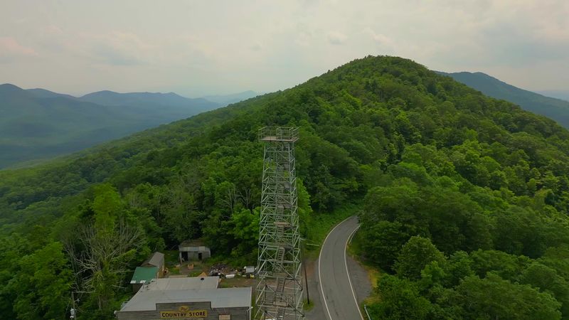
The Big Walker Lookout tower hums with wind before you even step from the car.
The byway climbs VA 52 toward a country store at 8711 Stoney Fork Rd, Wytheville, VA 24382, a longtime stop overlooking deep valleys.
Switchbacks tighten as the forest shifts between shadow and bright patches of sky.
Motorcyclists favor the route, moving with careful precision around the ridge’s sharper bends.
Stepping onto the swinging bridge near the tower offers a gentle sway and a wide-angle view of overlapping hills.
Local crafts and maps inside the store add a sense of memory to the climb.
Descending the mountain cools the air noticeably, marking each mile with a small change in temperature.
7. Mount Rogers Scenic Byway, Mount Rogers National Recreation Area
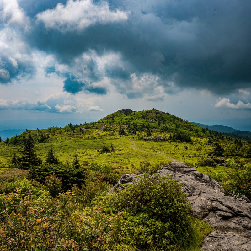
Wind presses across the high meadows near Whitetop, carrying the scent of spruce-fir from the balds.
The route follows VA 58 and VA 600 through Grayson Highlands, with orientation available at 3714 Highway 16, Marion, VA 24354.
Wild ponies graze along the ridges, appearing and disappearing like moving punctuation marks in the landscape.
Weather can shift abruptly, bringing fog or sleet even outside typical winter months.
Damascus serves as a welcoming trail town where a warm drink resets the pace before climbing again.
Massie Gap fills early, making sunrise a practical time to arrive if you plan to hike.
Blankets, extra layers, and steady patience make the high elevations feel more generous and less unpredictable.
8. Back Of The Dragon On VA 16 Between Marion And Tazewell
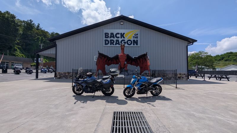
Tires whisper through more than 300 curves that rise and fall across the spine of the mountains like a restless wave.
VA 16 connects Marion and Tazewell with riders often gathering near 144 E Main St, Marion, VA 24354, where maps and weather updates circulate among regulars.
Elevation changes reset your ears while the landscape folds into sharp switchbacks carved by ancient coalfield geology.
Motorcyclists treat the route with a mix of excitement and caution, sharing gentle reminders about pacing and visibility.
Fueling up before committing to the full stretch becomes part of the ritual, especially when wet leaves complicate braking.
The overlook near the Hungry Mother State Park connector offers a moment to steady yourself before the next bends.
A coffee in Tazewell afterward turns the entire drive into a story told in long, winding breaths.
9. Chesapeake Bay Bridge Tunnel between Virginia Beach And The Eastern Shore
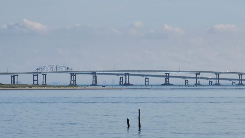
Salt gathers on the wind as gulls hover above the long trestles like tiny navigators riding the currents.
Opened in 1964, the CBBT crosses the mouth of the bay with bridges and tunnels maintained from 32386 Lankford Hwy, Cape Charles, VA 23310.
Cargo ships move slowly in the distance while the car shifts between open sky and enclosed tunnel echo.
Crosswinds can feel unpredictable, urging drivers to pay attention to posted restrictions for high-profile vehicles.
Sea Gull Pier, with its restricted but steady hours, provides a compact vantage point for watching the Atlantic push inland.
Timing the crossing at sunrise makes the water blush pink, giving the drive a quiet sense of ceremony.
The Eastern Shore’s tomato stands turn the journey’s end into something simple but grounding.
10. Appalachian Waters Scenic Byway On Route 39
The sound of moving water follows you through the gorge, from the riffles of the Maury River to the hush of Lake Moomaw.
Route 39 slips through Goshen Pass with access points near 1070 Maury River Rd, Lexington, VA 24450, where metamorphic rock shapes the river’s swift turns.
Roadside walls built during the New Deal era hug the cliffs like neat stitching that holds the byway together.
Kayakers scout rapids in spring, turning the river into a lively thread of movement against blooming azaleas.
Fuel grows scarce between Lexington and Warm Springs, so planning ahead becomes part of the slow-travel mindset.
The swinging bridge near Goshen gives a camera-ready pause with a view framed by boulders and fast water.
Bath County greets you with the clean, mineral scent of hemlock and springs that drift through the air.
11. Lake Gaston Byway In South Central Virginia
Shimmering coves mirror small docks that creak as boats settle against their ropes in the shifting light.
The byway passes through Mecklenburg and Brunswick counties, with many travelers orienting near 1775 Eaton Ferry Rd, Littleton, NC 27850 just across the state line.
Hydroelectric engineering at the dam shaped the lake’s outline and helped create a shoreline dotted with weekend houses.
Fishermen launch their boats at dawn, giving the water a subtle hum before the day grows warm.
Services cluster near Gasburg and Bracey, making them good starting points before wandering the quieter loops.
Driving across the Eaton Ferry Bridge at golden hour makes the lake seem to stretch farther than it actually does.
A simple stop at a family grill afterward gives the drive a laid-back, end-of-day rhythm.
12. Shenandoah County Back Roads Loop On Routes 11, 600, 675, 42, And 263
A patchwork of cornfields, low stone churches, and roadside produce stands unfolds steadily with each turn.
This loop passes through Woodstock, Edinburg, and Basye, with a natural pause at Bryce Resort at 1982 Fairway Dr, Basye, VA 22810.
The Massanutten’s long ridge remains visible like a quiet guide marking the edges of the landscape.
Curves tighten near Wolf Gap, where the road seems to settle deeper into the hills before opening again.
Farm stands often operate on the honor system, adding a gentle rural ritual to the drive.
The Victorian hotel in Orkney Springs appears unexpectedly between bends, lending a soft historical note to the route.
Tomatoes, peaches, and weather talk become common currency during stops, grounding the loop in everyday detail.
13. Journey Through Hallowed Ground Scenic Drive Section Along US 15
Stone walls and horse farms stretch along the road like a practiced script written across the hills.
The US 15 corridor moves between Leesburg and Culpeper with a notable landmark at Oatlands Historic House, 20850 Oatlands Plantation Ln, Leesburg, VA 20175.
Preservation easements maintain open sightlines that reveal the Piedmont as a layered record of Revolutionary and Civil War history.
Weekend traffic slows near schools and popular event venues, especially during autumn festival season.
Montpelier’s archaeological digs offer a deeper look into the region’s stories and reward a thoughtful detour.
The farm roads around the estate lengthen the sense of time, blending fieldwork and landscape.
A careful pace helps the drive feel reflective rather than rushed.
14. Daniel Boone Wilderness Road In Far Southwest Virginia
Quiet hollows open gradually as the road follows Boone’s historic path through the mountains.
US 58 and US 23 pass Natural Tunnel State Park, where the visitor center at 1420 Natural Tunnel Pkwy, Duffield, VA 24244 anchors the experience.
Rail lines and limestone formations appear in alternating glimpses that echo centuries of movement across the region.
Museums in Big Stone Gap bring added context, linking frontier stories with coal country history.
Weather shifts quickly between ridges, especially in spring and fall when fog settles low.
The chairlift at Natural Tunnel offers a grounded change in perspective before continuing the journey.
Redbuds and river breezes soften the final miles as the valleys widen again.
15. Clarke County Scenic Driving Tour In The Northern Piedmont
Gravel roads crunch softly under the tires as white-fenced pastures stretch toward the horizon.
The mapped route includes mill sites, riverside farms, and the State Arboretum at 400 Blandy Farm Ln, Boyce, VA 22620.
Stone banks and wide fields give the drive a sense of calm that deepens with each mile.
Narrow lanes require patience, especially where hedgerows tighten the space.
In late fall, the ginkgo grove carpets the paths in yellow and shifts the light into a muted glow.
Millwood’s waterways move at an unhurried pace that suits the rural character of the tour.
Birdsong along the Shenandoah River becomes a quiet companion when windows are cracked open.