Why Fly To Peru When Arizona Has Its Own Machu Picchu
I did not expect a place this quiet to feel so big. At first, it seemed like a simple desert stop, the kind of place I would wander through, admire for a few minutes, and then keep moving. But the longer I stood there, the more it started to feel like I had stepped into something much older and more powerful than the landscape first lets on.
The stone walls, the open sky, the dry wind, and the silence all work together in a way that feels strangely moving. It is not trying to be flashy, and that is exactly what makes it stay with you. You do not need a passport or a long flight to feel that sense of wonder.
Sometimes Arizona has it waiting right off the road, looking ancient, quiet, and completely unforgettable.
Built mostly after a nearby volcano erupted around 1085 CE, these red sandstone structures rise dramatically from the Painted Desert landscape and tell a story stretching back nearly a thousand years. Thousands of visitors make the long journey to Peru every year to walk among ancient ruins, but Arizona has been quietly keeping a remarkable secret of its own.
The Volcanic Backstory That Started It All

Before a single brick was laid at Wupatki, a volcano changed everything. Around 1085 CE, Sunset Crater Volcano erupted just a few miles away, blanketing the surrounding desert in a thick layer of volcanic ash and cinder.
Rather than destroying the land, that eruption accidentally made it more livable. The ash acted like a natural mulch, trapping moisture in the otherwise dry soil and making it possible to grow crops like maize, squash, and beans in a region that would otherwise be too harsh for farming.
Word spread fast across the Southwest. Different cultural groups, including the Sinagua, Cohonina, Kayenta Ancestral Puebloans, Hohokam, Mogollon, and Cibola peoples, all migrated toward the area within a few generations. What followed was a remarkable experiment in multicultural living, with different traditions, building styles, and trade goods all mixing together in one compact desert region.
The volcano, in a strange twist, planted the seeds of a thriving civilization. The result was a place that felt unusually alive for such a remote stretch of northern Arizona, with homes, gathering spaces, and daily routines taking shape under the wide desert sky.
That is what makes the story so fascinating: a disaster in the landscape ended up creating the conditions for people to build, farm, trade, and connect.
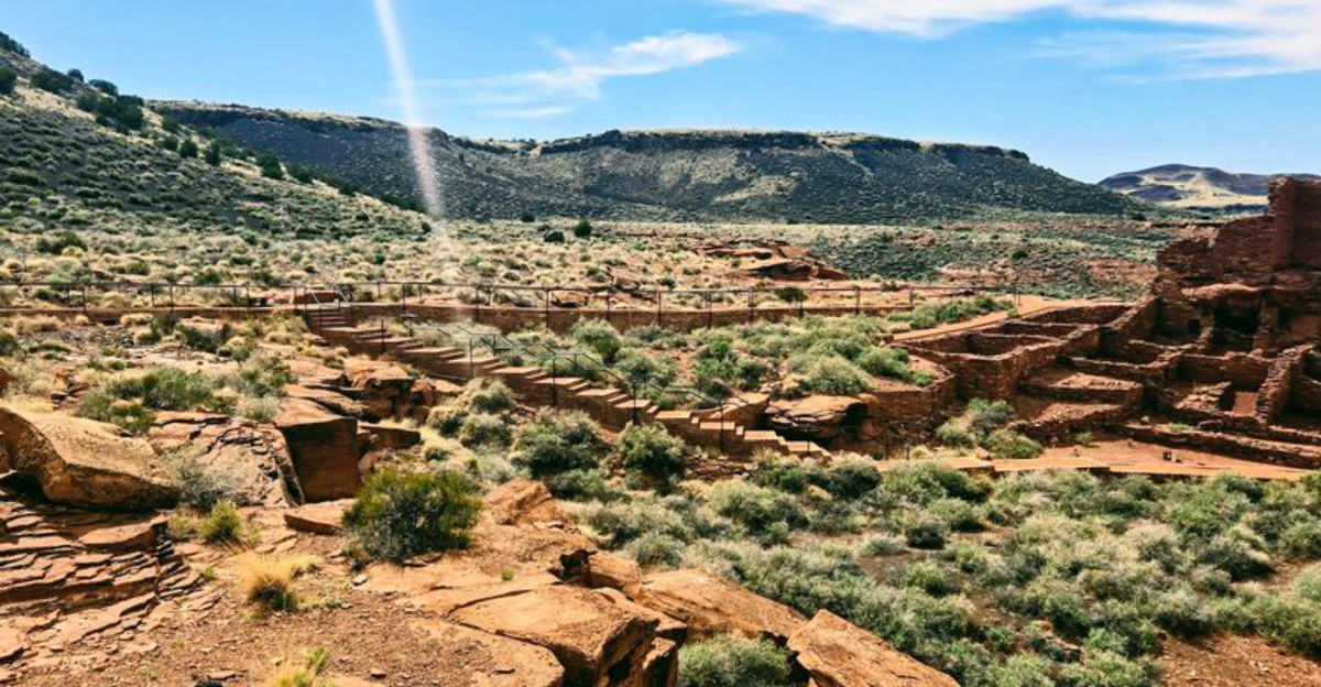
Wupatki Pueblo: The Largest Freestanding Pueblo In Northern Arizona

Standing at the heart of the monument, Wupatki Pueblo is impossible not to stare at. Built from local Moenkopi sandstone, its walls glow a deep rust red against the pale desert sky, and the structure climbs several stories in places, spreading across the rocky terrain like a small city frozen in time.
At its peak, the pueblo held over 100 rooms and sheltered up to 100 people, with thousands more living within a day’s walk. It served as a regional hub for trade, ceremony, and community life.
The building also features a ceremonial kiva, a sunken circular chamber used for spiritual rituals, and a formal ball court, the northernmost ever found in North America.
That ball court is a remarkable detail on its own, pointing to deep connections with Mesoamerican cultures far to the south. Visitors today can walk a short paved trail directly around the pueblo, reading interpretive signs that bring each crumbling wall back to life with surprising clarity.
It is one of those places where the details matter, because every doorway, wall line, and open space hints at how carefully this community was planned.
The more you look, the less it feels like a ruin and the more it feels like a reminder that this desert once held a busy, connected world.
A Multicultural Crossroads Unlike Anywhere Else

Most ancient sites in the American Southwest were built and occupied by a single cultural group, which is what makes Wupatki so unusual. Artifacts found here tell a story of people from remarkably different backgrounds living side by side and trading with one another across vast distances.
Excavations have uncovered pottery styles from multiple regions, copper bells and macaw feathers from northern Mexico, seashells from the Pacific and Gulf Coasts, and turquoise from mines scattered across the Southwest.
Each object is a small piece of evidence pointing to a web of trade routes that stretched for hundreds of miles in every direction. Archaeologists describe the area as one of the most culturally diverse communities in the prehistoric Southwest, a place where different peoples apparently coexisted and shared ideas rather than competing.
That spirit of exchange feels almost modern when you think about it. Walking among the ruins, you get the sense that this was not just a settlement but a meeting place, a crossroads where the ancient world came together.
The Sacred Blowhole And Its Connection To Indigenous Spirituality

Near the base of Wupatki Pueblo, there is a narrow crack in the earth that breathes. Known as a blowhole, this natural geological feature pushes air up from underground cave systems when atmospheric pressure changes, creating a steady rush of wind that can be felt even on a perfectly still day.
For many Indigenous peoples connected to this land, the blowhole is far more than a geological curiosity. It is considered a sacred connection between the world of the living and the spiritual realm below.
Hopi elders have reportedly used the blowhole to observe changes in airflow as a way of predicting shifts in weather patterns, treating it as a kind of living instrument tied to the natural world.
Today, numerous Indigenous nations, including the Hopi, Navajo, Havasupai, Zuni, Yavapai, and Apache, maintain active ties to Wupatki and continue to regard the land as sacred.
The Hopi believe the former inhabitants remain as spiritual guardians watching over the site, a belief that adds a quiet reverence to every visit.
Exploring The Other Ruins: Wukoki, The Citadel, Lomaki, And Box Canyon

Wupatki Pueblo gets most of the attention, but the monument contains over 2,700 cultural sites spread across 55 square miles of the Painted Desert, and several of them are absolutely worth the short drive along the 36-mile loop road.
Wukoki Pueblo looks like a fortress perched on a volcanic rock outcropping, its three-story tower rising sharply against the open sky in a way that feels almost cinematic.
The Citadel sits on a low mesa and once commanded sweeping views of the surrounding desert, while Lomaki features a cluster of small, elegant rooms connected by a shared courtyard. Box Canyon is quieter and more tucked away, with ruins nestled into a narrow stone canyon that offers natural shelter from wind and weather.
Each site has its own personality and its own story, and visiting all of them in a single day is completely doable. Pack water, wear sturdy shoes, and give yourself enough time to pause at each stop rather than rushing through, because the details reward a slow and curious eye.
The Painted Desert Setting: A Landscape That Earns Its Name

The ruins at Wupatki are extraordinary on their own, but the landscape surrounding them deserves equal attention. The monument sits within a section of the Painted Desert, a vast expanse of layered rock and sediment that shifts through shades of red, orange, purple, and cream depending on the time of day and the angle of the light.
Early morning and late afternoon are when the colors really perform, with the low sun dragging long shadows across the terrain and turning the sandstone walls of the pueblos into something that glows.
The elevation sits around 4,900 feet, which keeps temperatures more comfortable than the lower desert regions of Arizona, though summers can still be warm and winters bring genuine cold.
Wildlife is present throughout the monument, including pronghorn antelope, ravens, lizards, and the occasional prairie dog colony near the visitor center.
The sheer openness of the landscape, with its wide skies and distant mesas, gives every photograph a natural drama that requires almost no effort to capture.
Planning Your Visit: Practical Tips For Getting The Most Out Of Wupatki

Wupatki National Monument is located at 25137 N. Highway 89, Flagstaff, AZ 86004, and is accessible year-round, though spring and fall offer the most comfortable conditions for walking the outdoor trails.
The entrance fee is included with an America the Beautiful pass, or can be paid separately at the visitor center.
The 36-mile scenic loop road connects the main sites and can be driven in about two to three hours if you stop at each pullout, though a full day allows for a much more relaxed and rewarding experience.
The visitor center near Wupatki Pueblo has excellent exhibits, clean restrooms, and knowledgeable rangers who can answer questions and offer context that makes the ruins feel alive rather than just old.
Cell service is limited throughout the monument, so download offline maps before leaving Flagstaff. Bring more water than you think you need, especially in summer.
The combination of ancient history, dramatic scenery, and genuine quiet makes Wupatki one of the most underrated road trips in the American Southwest.