13 Winter Hiking Trails In Oregon That Will Take Your Breath Away
Oregon transforms into something magical once winter arrives and snow blankets the mountains, forests, and volcanic peaks.
Trails that see crowds all summer suddenly turn quiet and peaceful, offering hikers a chance to explore landscapes covered in fresh powder and ice.
Frozen waterfalls, snowy lakeshores, and ridgelines with views that stretch for miles become the reward for anyone willing to bundle up and head outside.
Winter hiking here requires a bit more planning than summer adventures, but the payoff is worth every cold step.
Grab your snowshoes, pack extra layers, and get ready to discover trails that prove Oregon’s beauty does not take a break just because the temperature drops.
1. Mirror Lake Loop – Mount Hood National Forest, near Government Camp
Some winter mornings, I leave Portland in the dark just so I can watch the light change over Mirror Lake.
The trail starts from the Mirror Lake Trailhead along Highway 26 near Government Camp, climbing steadily through forest for about 2 miles before the trees open around the frozen shoreline. I strap on microspikes or snowshoes depending on how deep the snow is, because the packed sections can turn slick.
Once I reach the lake, a short loop lets me wander between snowy trees and peek through gaps where Mount Hood reflects in any open water that has not frozen yet. Ambitious days tempt me farther toward Tom Dick and Harry Mountain, but even the basic lake circuit feels generous enough.
When I head back down, weaving between families, photographers, and tired dogs, I understand why this modest loop stays busy through almost every winter storm cycle.
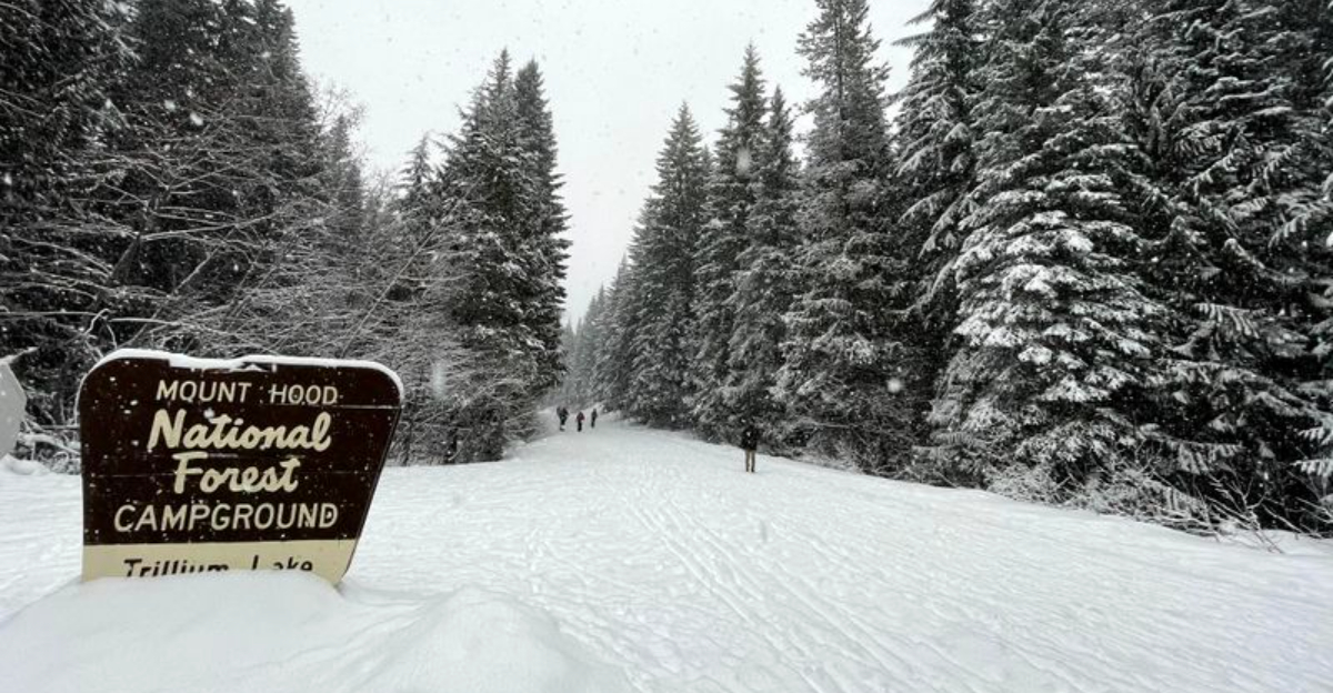
2. Trillium Lake Winter Loop – Mount Hood National Forest, near Government Camp

Snow crunches under my boots long before I see Trillium Lake hiding in the trees.
Starting from Trillium Sno-Park off Highway 26 near Government Camp, I follow the wide, packed trail that circles the frozen lake and passes through thick evergreens weighed down with fresh snow. This 4 to 5-mile loop is popular but still feels peaceful, especially on weekday mornings when skiers and snowshoers glide past in friendly silence.
I always remember my Sno-Park permit, because rangers actually check here between November and April.
On clear days, Mount Hood suddenly appears across the lake, bright and snowy above the dark trees, and I end up standing still much longer than I planned. By the time I finish the loop and reach the big parking lot again, my camera battery is low, my cheeks are cold, and my legs are happily tired from one of the easiest winter rewards on the mountain.
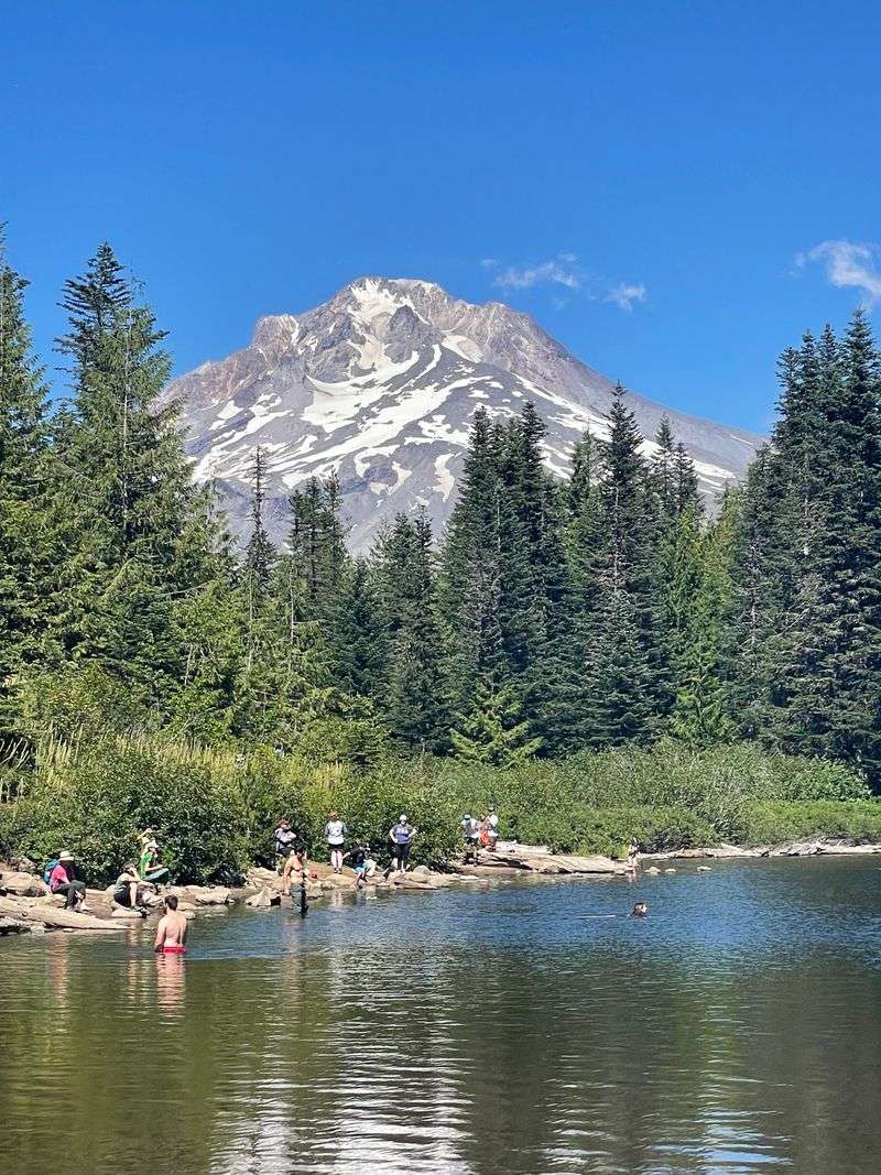
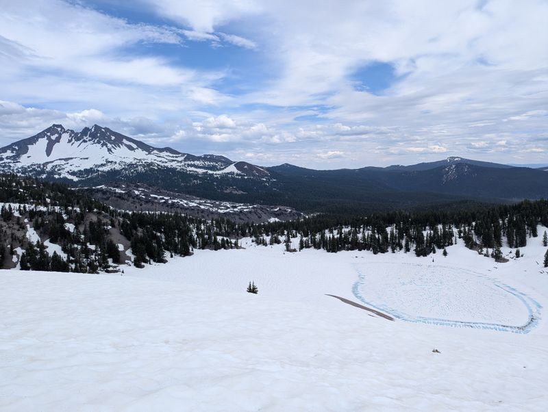
3. White River West Sno-Park – Mount Hood, near Government Camp

On clear afternoons, I cannot resist the pull of the White River West Sno-Park and its direct view of Mount Hood.
From the huge parking area off Highway 35, just north of the Highway 26 junction, a broad snowy corridor follows the White River canyon uphill toward the mountain. I keep my route simple, snowshoeing a few miles up the drainage and staying well back from cornices and steeper side slopes, because this valley earns its avalanche warnings.
The reward is a slow unfolding of Hood itself, the peak growing larger and more dramatic as the river noise fades into the snow.
On busy weekends, the sno-park fills quickly with sledders, skiers, and families building questionable snow sculptures, so I try to arrive early and park near the upper end. Walking back down at sunset with the sky turning pink behind the summit, I always feel as though I squeezed a whole mountaineering day into a casual out-and-back.
4. Pocket Creek Sno-Park Loops – Mount Hood east side, near Parkdale

When I want quieter snow and a dog-friendly route, I drive around Hood to the Pocket Creek Sno-Park.
The small lot on the mountain’s drier east side leads into a network of ungroomed loops through hemlock and pine forest, with occasional openings that line up a clean view of Mount Hood. I follow blue diamonds and old road grades, picking a route that usually ends up between 4 and 6 miles, depending on my energy and snack supply.
A Sno-Park permit is required here from November through April, and I like knowing that rule keeps the plowed access reliable.
Compared with the chaos at Trillium or White River, the mood at Pocket Creek stays calm, just the sound of snowshoes, the occasional skier, and the soft huff of happy dogs. Every time I glide back into the lot with Hood glowing above the treeline, I wonder why I do not choose this less crowded side of the mountain more often.
5. Salt Creek Falls and Diamond Creek Falls Loop – near Oakridge
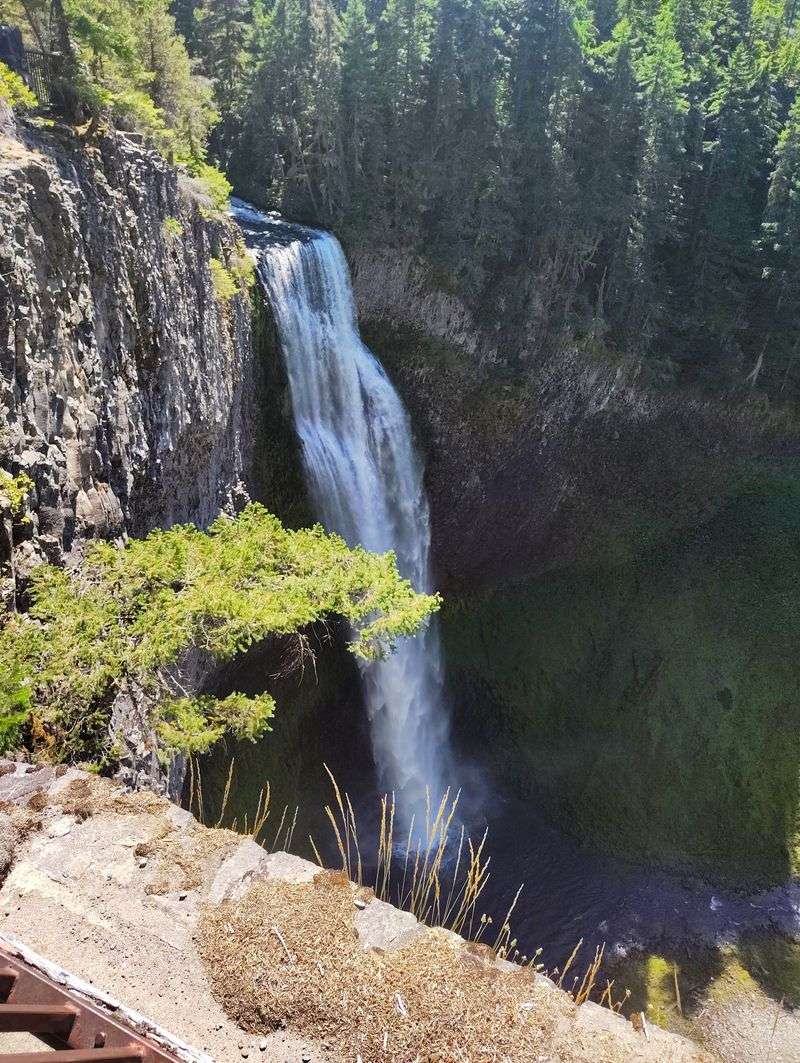
Some winter days, I drive east from Eugene until the highway starts collecting snowbanks, then pull into Salt Creek Sno-Park.
From the plowed lot near Willamette Pass, a short, packed path leads to a dramatic viewpoint of Salt Creek Falls, one of Oregon’s tallest waterfalls, plunging into a snowy canyon. On good conditions days, I clip into snowshoes and follow the marked loop toward Diamond Creek Falls, crossing quiet forest, small bridges, and signed junctions that are surprisingly easy to follow in the trees.
The full loop runs a little over 3 miles, with rolling elevation that keeps my lungs honest without ever feeling punishing.
I take my time at each overlook, listening to the low roar of water under snow and watching mist hang in the cold air. Walking back toward the sno-park, often with only a handful of cars in the lot, I always feel as though I found a winter waterfall circuit that should be far busier than it is.
6. Tumalo Falls via Tumalo Creek Trail – Deschutes National Forest, near Bend
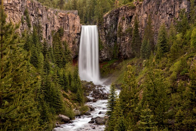
Whenever fresh snow hits the Cascades, I start checking whether the gate on the road to Tumalo Falls has closed.
In winter, drivers park back at the seasonal closure on Forest Road 4603 and turn the remaining roadway into a 7-mile round-trip snowshoe or ski along Tumalo Creek to the main viewpoint. The route follows a gentle climb through thick forest, passing bridge crossings and occasional clearings where the creek noise grows louder.
I stay on the road and stop at the big overlook above the 97-foot waterfall, because the unmarked side trails beyond are not recommended for winter travel.
Even so, the view of the falls framed by snow-covered canyon walls feels dramatic enough to count as a full day’s adventure. By the time I glide back to the gate, usually racing dusk a little, I understand why so many Bend locals treat this outing as their go-to winter cardio session.
7. Dutchman Flat Sno-Park Loops – near Mount Bachelor and Bend
On bluebird days above Bend, I drive up Century Drive until the world turns completely white around Dutchman Flat Sno-Park.
This high elevation playground near Mount Bachelor sits at the edge of broad meadows and forested ridges, with a maze of marked ski and snowshoe routes that can be stitched into anything from a quick 3-mile loop to a long wandering tour. I check the trail maps at the kiosk, stay off the snowmobile corridors, and follow blue diamonds through open glades with big views of Bachelor and Broken Top.
The snowpack here usually stays deep from November into spring, and a Sno-Park permit is required for parking.
On windy afternoons, I love ducking into the trees, letting the forest block the gusts while I snack and watch skiers glide silently past. Driving back down toward Bend after sunset, with the sky fading over Bachelor, I always feel that Dutchman gave me a full day’s winter fix without needing a lift ticket.
8. Swampy Lakes Snowshoe Loops – near Bend

When I want a quieter alternative to Dutchman but still crave deep snow, I turn to Swampy Lakes Sno-Park.
The trailhead sits along Century Drive west of Bend and connects to several marked snowshoe-only loops, including the Porcupine route and shorter circuits that weave through dense pine forest. I usually aim for a 3 to 5-mile outing, following trail junction signs toward viewpoints of Swampy Lakes and nearby buttes, and appreciating how easy the navigation feels even on snowy days.
Dogs are not allowed here in winter, which keeps the trails focused on skiers and snowshoers and avoids the usual tangle of leashes.
There is a simple warming shelter nearby for longer outings, but most of my trips end with me lingering at the trailhead, staring back into the trees and thinking about squeezing in just one more loop. Snow-covered branches, steady elevation, and relative solitude always combine into exactly the midwinter reset I was looking for when I left town.
9. Virginia Meissner Sno-Park Snowshoe Trails – near Bend

Some evenings after work in Bend, I can be clicking into snowshoes at Virginia Meissner Sno-Park before my brain fully believes I left the office.
Located off Century Drive, about 15 miles from town, this community Nordic area offers nearly 40 to 50 kilometers of groomed ski tracks plus two dedicated snowshoe routes that wind through thick pine forest to shelters with benches and wood stoves. I pick a loop of 2 to almost 3 miles, following clearly marked snowshoe junction letters and staying off the groomed classic and skate lanes.
A Sno-Park permit is required here in winter, and dogs are not allowed, which keeps the atmosphere orderly and calm.
Reaching a shelter with steam rising from everyone’s thermoses and frost building on my jacket, I always feel grateful that a full winter trail network hides this close to town. The glide back to the parking lot under headlamp beams might be short, but it turns an ordinary weeknight into something I remember for days.
10. Misery Ridge and Summit Trail Loop – Smith Rock State Park, near Terrebonne
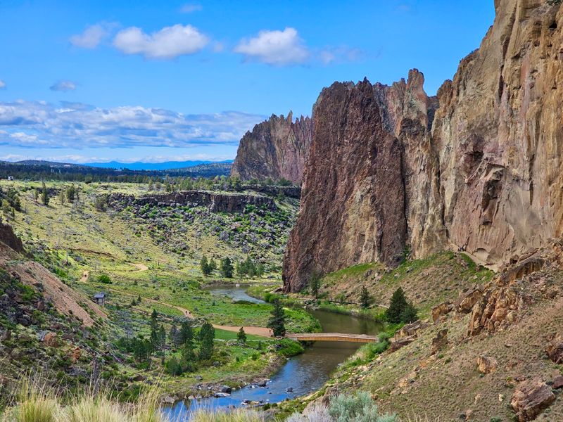
On crisp winter mornings in Central Oregon, I trade snow covered forests for the rock spires of Smith Rock and point my boots toward Misery Ridge.
The classic loop leaves from the main day-use area near Terrebonne, crosses the bridge over the Crooked River, then climbs steep switchbacks toward panoramic viewpoints that make the name feel more dramatic than necessary. Snow and ice linger in shaded sections, so I carry traction and take those steeper steps carefully, especially near the exposed edges.
Once on top, I wander along the ridge, watching the river loop far below and scanning the skyline of the Cascades, often dusted white in the distance.
The descent drops back to the river and follows the Summit Trail or River Trail past climbing walls and quiet winter wildlife. By the time I return to the parking lot, cheeks flushed from cold air and climbing, I am usually already planning which direction I will walk the loop next time.
11. Latourell Falls Loop – Columbia River Gorge, near Corbett
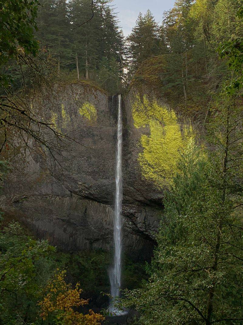
When the Gorge feels too crowded in summer, I save Latourell Falls for a chilly winter weekday and enjoy the quieter mood.
The loop begins from Guy W. Talbot State Park, just off the Historic Columbia River Highway near the small community of Latourell, and climbs a 2 to 2.4-mile circuit past both Lower and Upper Latourell Falls. In winter, the basalt amphitheater around the lower falls can grow icy, so I tread carefully and keep a respectful distance from the spray zone.
The upper falls hide in a mossy side canyon, and snow on the railings and bridges adds a little extra drama for the photos I cannot resist stopping to take.
Even when the parking lot never completely empties, this short, moderate loop feels surprisingly peaceful once I step away from the main viewpoint. Driving back toward Portland with damp boots and waterfall spray still clinging to my jacket, I always feel glad I did not let a little cold rain keep me indoors.
12. Trail of Ten Falls – Silver Falls State Park, near Silverton
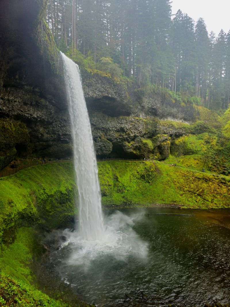
On moody winter days when clouds hang low over the Willamette Valley, I head for Silver Falls State Park and its famous waterfall loop.
The Trail of Ten Falls winds roughly 7 to 9 miles through deep forest, passing behind or beside a series of cascades that thunder much louder when winter rain and snowmelt swell the creeks. Park staff describe the trails as open year-round but often icy, especially near viewpoints where spray freezes, so I bring good traction and move carefully along the rock ledges.
Some days I tackle the full loop, other days I stitch together shorter segments from the South Falls trailhead, happy just to hear the roar in the canyon below.
Occasional snow dusts the big trees here, but even plain winter rain feels right in a park built around water. By the time I climb back to the rim and reach my car, soaked and smiling, I usually decide that no season shows off these falls better than the colder months.
13. Cape Lookout Trail – Cape Lookout State Park, Oregon Coast near Tillamook
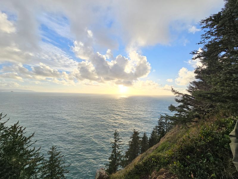
When mountain roads feel sketchy, I aim my winter hikes toward the coast and the narrow spine of Cape Lookout.
From the trailhead in Cape Lookout State Park, southwest of Tillamook, a roughly 4.5 to 5-mile out-and-back path follows a forested ridge that juts far into the Pacific, with dizzying viewpoints dropping hundreds of feet to the waves.
Winter here usually brings mild temperatures compared with the Cascades, but it also delivers relentless mud, slick roots, and strong wind on the exposed points, so I dress for rain and keep my footing deliberate.
Park updates note that Cape Lookout State Park is scheduled for construction-related closures in 2026, so I always check the latest notices about campground and trail access before planning a hike here.
On stormy days, watching swells crash far below while clouds race overhead feels almost hypnotic.
When I finally turn back toward the parking lot, shoes thoroughly baptized in coastal mud, I always feel that this windswept peninsula delivered a winter hike every bit as memorable as any snowy summit.