You Can Literally Drive To This Colorado Overlook With Unreal Mountain Views
I still remember the first time I steered onto Mount Evans Scenic Byway at 20540 Mount Evans Hwy, Idaho Springs, CO 80452, wondering if my car could actually handle what lay ahead.
The answer turned out to be yes, but my expectations got completely rearranged along the way as the road kept climbing and the air thinned with every mile.
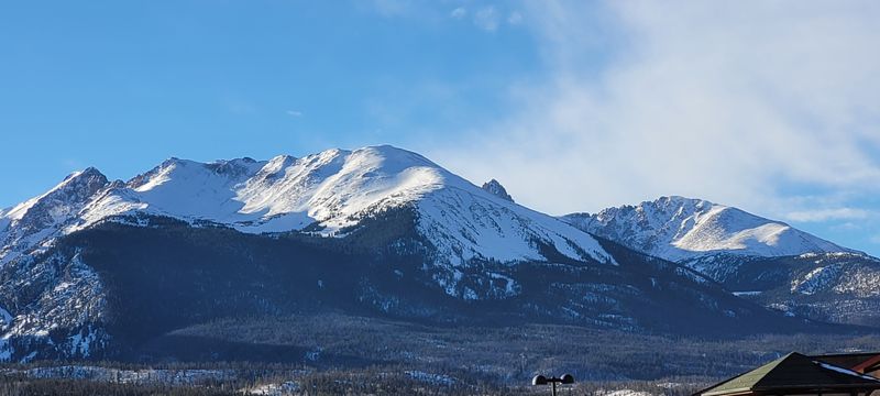
This stretch of asphalt rises higher than almost any other paved road in North America, winding through dense forests, open alpine tundra, and exposed rocky ridges that make you feel like you stepped into someone else’s adventure postcard.
Each hairpin turn delivers another sweeping view that makes you question whether your camera can do justice to what your eyes are seeing, and spoiler alert, it probably cannot.
Wildlife appears without warning, clouds drift at eye level, and the silence feels enormous.
It is a reminder of how dramatic and accessible Colorado landscapes can be, offering an unforgettable drive that shows off Colorado at its most awe inducing.
Reaching the Summit Without Breaking a Sweat
Driving to 14,130 feet sounds like the kind of boast reserved for mountaineers with ice axes and crampons, but Mount Evans Scenic Byway lets you pull it off in your sedan. The road itself snakes upward for 28 miles, starting near Idaho Springs and ending just shy of the summit, where a short trail finishes the job.
I found myself shifting into lower gears more often than I expected, not because the road demands it, but because slowing down meant I could actually absorb the view instead of white-knuckling past it. Guardrails appear in the spots that matter most, though plenty of open stretches remind you that this is not your average Sunday drive.
Wildflowers carpet the roadside in July, alpine lakes reflect the sky like polished mirrors, and bighorn sheep sometimes wander onto the pavement as if they own the place. The air gets thinner as you climb, so taking breaks at pullouts becomes both a scenic necessity and a lung-friendly strategy.
By the time I reached the top, I realized the byway had delivered an alpine experience without requiring me to pack a single hiking boot.
Wildlife Encounters That Feel Almost Scripted
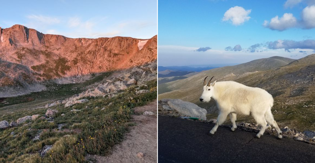
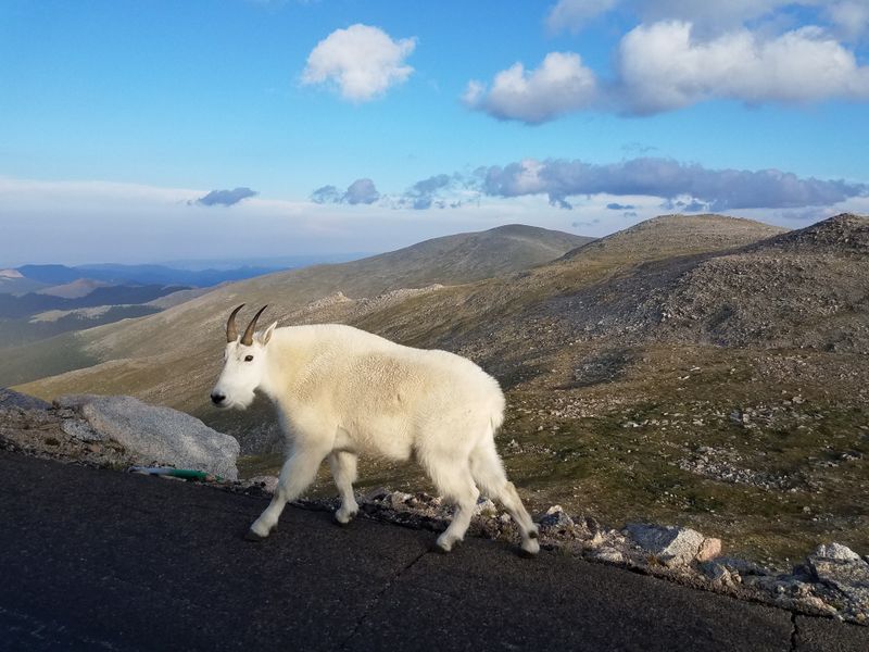
Bighorn sheep treat the byway like their personal runway, and I am not exaggerating when I say they seem to pose for photos. These animals have adapted to the high-altitude environment so well that they barely flinch when cars roll past, though I kept a respectful distance because wild is still wild.
Mountain goats also make appearances, usually perched on cliffs that look too steep for anything with hooves. Yellow-bellied marmots whistle from boulder piles, and if you visit in late spring or early summer, you might spot elk grazing in the meadows near the lower elevations.
I learned quickly that patience pays off here. One afternoon, I sat in a pullout for twenty minutes watching a family of marmots play-fight on a rock, and it became the highlight of my trip.
The byway passes through multiple ecosystems, so the wildlife changes as you climb. Down low, you might see deer or foxes, while the upper reaches belong to species that thrive in the thin air and harsh weather.
Every encounter felt like a reminder that I was the visitor in their home, not the other way around.
Timing Your Trip to Dodge the Crowds and Weather
The byway opens around Memorial Day and closes after the first serious snowfall, usually in September or early October, so your window is shorter than you might think. I made the mistake of visiting on a July Saturday around noon, and the parking lot at the summit looked like a theme park entrance.
Early mornings became my secret weapon. Arriving at sunrise meant I had entire stretches of road to myself, and the light at that hour turned the peaks into glowing sculptures.
Weather shifts fast at this elevation, so I started checking forecasts obsessively before each trip. Afternoon thunderstorms roll in regularly during summer, and lightning above treeline is not something you want to gamble with.
Weekdays in June or September offer the best combination of open roads, stable weather, and fewer tour buses. I also learned to pack layers, because starting in a T-shirt at Idaho Springs and needing a winter jacket at the summit is completely normal.
One ranger told me that the byway sees its heaviest traffic between 10 a.m. and 3 p.m., so planning around those hours made my experience infinitely more peaceful.
Pullouts That Deserve More Than a Quick Glance
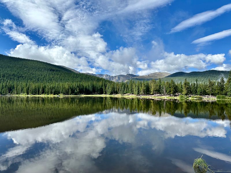
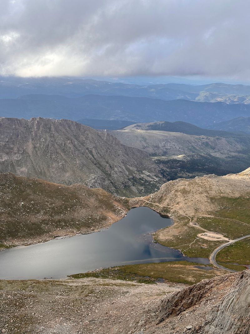
The byway includes more than a dozen official pullouts, and I initially treated them like pit stops for adjusting my rearview mirror. That changed when I actually stopped at Echo Lake, where the water reflects Mount Evans so perfectly that it looks like someone Photoshopped the scene.
Summit Lake sits just below the peak, and despite its name, it feels more like a high-altitude pond surrounded by tundra. I watched pikas dart between rocks here, their tiny squeaks echoing off the cliffs.
Another pullout near the alpine zone offers views of the Continental Divide, and on clear days, you can trace the ridgeline for miles. I spent thirty minutes here once, just watching clouds drift through valleys below me.
Each pullout comes with interpretive signs that explain the geology, ecology, or history of the area, which I ignored at first and then regretted skipping. The information added context that made the views even more impressive.
I started building extra time into my trips specifically for these stops, because rushing past them felt like flipping through a coffee table book without reading the captions.
Navigating the Road’s Technical Challenges
Hairpin turns outnumber straight sections by a landslide, and some curves feel tight enough that I instinctively held my breath even though my compact car had plenty of room. Larger vehicles, especially RVs, require more attention and slower speeds, but the road is wide enough to handle them.
Grades can hit 7 percent in spots, so downshifting on the descent saves your brakes from overheating. I learned this the hard way when I smelled burning rubber halfway down and had to pull over to let things cool.
The pavement stays in decent shape, though frost heaves and potholes pop up near the summit where freeze-thaw cycles hammer the asphalt year-round. I kept my speed moderate and my eyes scanning ahead, which also gave me more time to spot wildlife.
Cell service cuts out above treeline, so downloading maps or directions beforehand makes sense. I relied on a paper map once when my phone became a useless rectangle of glass.
The byway charges a small entrance fee, and the booth near Echo Lake accepts cash or card, making it easy to pay without digging through your glove box for exact change.
Alpine Tundra That Feels Like Another Planet
Above 11,500 feet, trees give up entirely, and the landscape transforms into something that belongs on a nature documentary about extreme environments. I found myself staring at patches of ground that looked barren from a distance but turned out to be covered in tiny wildflowers when I crouched down.
The tundra here is fragile, and signs everywhere remind visitors to stay on designated paths because a single footprint can take decades to heal. I stuck to the trails, partly out of respect and partly because the uneven ground made wandering off-trail more trouble than it was worth.
Wind blows constantly at this elevation, and I underestimated how much colder it feels when air is moving at 30 miles per hour. My sunglasses became essential gear, not for style but to keep grit out of my eyes.
The tundra blooms briefly in July and August, painting the ground in purples, yellows, and whites that contrast sharply with the gray rock. I visited in late June once and saw mostly brown, so timing matters if you want the full floral show.
Standing in this ecosystem made me appreciate how tough these plants are, thriving in conditions that would kill most garden varieties in hours.
Summit Lake and the Final Push to the Top
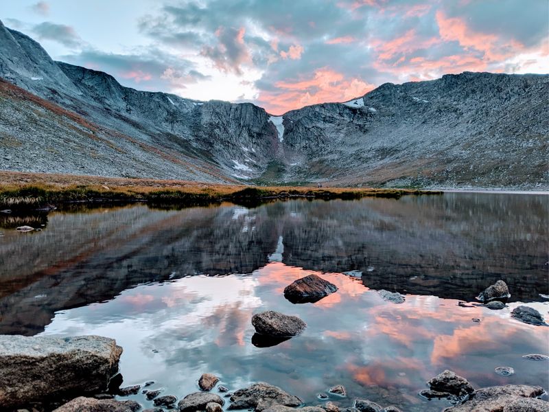
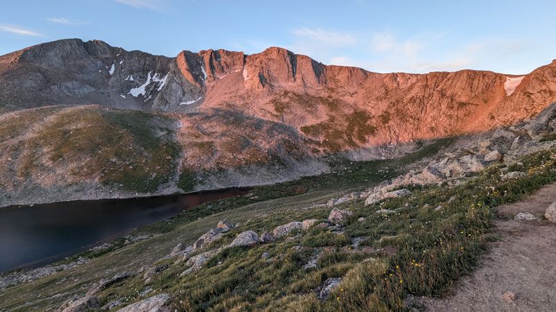
Summit Lake marks the last stop before the road ends, and I always lingered here longer than planned because the setting demands it. The water sits at 13,000 feet, making it one of the highest lakes you can drive to in North America, and the reflections on calm mornings rival anything I have seen in glossier destinations.
A short trail circles the lake, and I walked it once just to say I hiked above 13,000 feet without actually breaking a sweat. The path is easy, though the thin air made me breathe harder than the terrain justified.
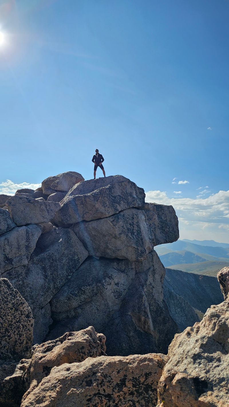
From the lake, a paved trail climbs the final 130 vertical feet to the summit, where a stone shelter built in the 1940s offers protection from wind and a place to catch your breath. I reached the top on a clear day and could see peaks stretching into Wyoming.
The summit itself feels less like a dramatic pinnacle and more like a rocky plateau, but the 360-degree views compensate for any lack of Hollywood drama. I stood there longer than I intended, trying to memorize the way the light hit the ridges.
Descending back to Summit Lake felt like stepping down from the roof of the world, and I realized the byway had delivered exactly what it promised.