This Scenic Arkansas Hike Leads To A Hidden Staircase Cascade
At some point on this Arkansas trail, you realize the creek has taken over the whole hike.
You hear it before you see the best part. Water moves over stone, boots scrape along the path, and the forest seems to keep the whole scene quiet on purpose.
This is not one of those hikes where you park, snap a photo, then leave five minutes later. Follow the bends.
Cross the creek. Keep trusting the trail.
Then comes the waterfall, shaped like steps and spilling down the rock in a way that makes people stop mid-sentence.
I came looking for a hike with more life than a simple overlook. This one had it.
Mud on the shoes. Cool air by the water.
That little rush of finding something worth the walk. Keep reading, because this trail keeps changing as you go.
Creekside Views Beneath The Ozark Canopy

The first stretch beside North Sylamore Creek makes it easy to see why this trail pulls people back for repeat visits there.
The canopy above the creek corridor is thick and layered, with hardwoods and pines competing for sky in that effortless way only old forests manage to pull off.
Light hits the water at angles that shift constantly as you move, turning the creek surface into something that looks almost painted rather than real.
Minnows dart through shallow riffles near the bank, and if you slow down long enough, you start noticing the small details that busy hikers usually miss, like the way moss clings to submerged stones or how the current bends around a fallen log.
The water often runs clear enough to make the shallow creekbed part of the scenery instead of just background noise.
The trail runs close enough to the creek in many sections that you can hear the water even when you cannot see it.
That calm, personal feeling starts right away at North Sylamore Creek Trail: Allison Trailhead at Unnamed Road, Mountain View, AR 72560.
Limestone Bluffs Along A Quiet Forest Trail

One of the first things that caught my eye beyond the creek itself was the rock. The bluffs rise suddenly from the forest floor, almost like walls that forgot to come with a building attached.
The North Sylamore Creek Trail is known for its limestone bluffs and rugged rock formations. These bluffs give the route a dramatic vertical dimension that flat-terrain hikers rarely experience on wooded creek trails in this part of the Ozarks.
In some sections, the trail hugs the hillside closely enough that you are essentially walking a narrow ledge with the bluff face on one side and a steep drop toward the creek on the other.
People who are uneasy with heights may want to know this before heading out, especially if they are bringing younger kids or anyone who prefers wide, open paths.
The rock itself is fascinating up close, streaked with mineral staining and hosting small ferns and mosses in every available crack.
Under one of the taller bluff sections, the scale feels impressive, and I found myself pausing there longer than I had planned, just taking in the scene.
Clear Water Pools Framed By Woodland Light

Forget every murky swimming hole you have ever reluctantly waded into, because the pools along this creek can run clear enough to make the creekbed part of the view.
Near the Allison Trailhead, the creek bends against a tall bluff and forms a deeper swimming area just south of the parking area, with cool water that feels especially welcome on hot summer days.
You may see rope swings or people jumping from rocks when water levels are higher, but that should never be treated as a built-in attraction or a guaranteed safe choice alone here, especially if the depth is uncertain.
The woodland light that filters down to the water surface shifts throughout the day, making the pool look different at noon than it does in late afternoon, when the angle turns everything golden and slightly dreamy.
Small fish often move through the shallows near swimmers, adding a quiet little detail that makes the creek feel alive rather than staged.
If you are visiting purely for a swim rather than a long hike, this pool alone justifies the drive out to the trailhead on a warm Arkansas afternoon.
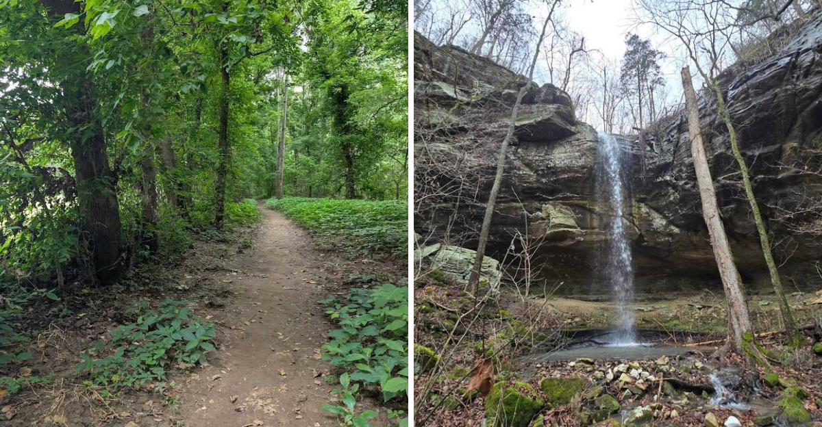
A Staircase Cascade By The Old Dam

Here is the detail that surprised me when I started researching this trail: the staircase-style cascade is not entirely a product of nature working on its own timeline.
The distinctive stepped appearance comes from the historic Gunner Pool Dam. This stone structure is tied to Civilian Conservation Corps work from the New Deal era, when crews built public-land infrastructure across the country.
That backstory gives the cascade a layered meaning that purely natural waterfalls do not carry, because every stone in that structure points back to human labor during one of the country’s most economically difficult periods.
This waterfall-like scene is tied to the Gunner Pool Recreation Area section of the wider trail system, so it should not be described as a guaranteed payoff from every Allison Trailhead hike.
Water is usually most impressive from late winter through early summer, especially after recent rain, and it may look far less dramatic during dry spells or long stretches without steady Ozark rainfall nearby.
During dry months, the flow can weaken, so planning around current conditions is useful, not just nice advice.
When the water is running well, the staircase effect is striking enough to make the whole route feel like it was building toward exactly that moment.
Ridge Views Above The Sylamore Valley

Higher sections on this trail change everything about the experience. The ridge areas above the valley floor offer a completely different perspective from the creekside stretches below.
The North Sylamore Creek Trail covers roughly 22 to nearly 24 miles point-to-point. Along the full route, lower creekside stretches give way to higher ridges across the broader North Sylamore trail system.
From the higher sections, the valley spreads out below in a way that makes you appreciate just how much forested land still exists in this part of Arkansas, with very little development interrupting the green.
The trail is marked with blue blazes throughout, which makes navigation manageable even in sections where the path becomes less obvious due to leaf cover or storm damage from past weather events.
Some portions of the trail near the Blanchard Springs and Allison areas have been closed at times due to storm damage, so checking current Forest Service conditions before heading out is a practical step worth taking seriously.
A ridge overlook above the Sylamore Valley is one of those trail moments that earns its place in your memory long after the soreness fades afterward.
Mossy Stone Steps Near The Waterfall

Close to the staircase cascade, the setting shifts into one of the most texturally rich parts of the entire trail system, where old stonework and damp rock surfaces can turn vivid green after wet weather.
The Civilian Conservation Corps connection behind the staircase effect also gives the structure a sense of age, with moss and moisture softening the edges over time in a way that matches the damp creekside setting around it today.
Photos in this area reward patience, because the light shifts noticeably depending on cloud cover and time of day, and the difference between a flat midday shot and a late-afternoon frame with warm side lighting is substantial.
The ground near the cascade requires attention, since moss-covered stone is predictably slippery when wet, and the area around the waterfall can stay damp even during periods of lower water flow.
Trail shoes or boots with grip are not optional here, it is the kind of decision that decides if you end the day with a great story or a bruised dignity.
The combination of historic stonework and running water creates a setting that feels old in the best possible way, as if the forest has been slowly reclaiming this structure for its own decorative purposes, one wet season after another.
Wild Scenic River Moments In The Ozarks

North Sylamore Creek does not just sit quietly beside the trail waiting to be admired; it feels like part of the hike. The water along this route can shift from calm to forceful depending on recent rainfall.
Small watercraft may appear in some areas when conditions allow, but hikers should not expect constant boat traffic along the Allison Trailhead stretch.
Near the trailhead, swimmers and waders need extra common sense after steady rain, because the same creek that looks inviting in calm weather can become fast and pushy when water levels rise.
The creek’s character changes noticeably with the weather: after heavy rain, the current can run strong enough to make swimming inadvisable, while during calmer periods the water settles into gentle riffles and deep pools that invite you to linger.
For hikers who do not paddle, simply watching the creek from the bank during high water is its own kind of entertainment, with the sound and movement of the current filling the forest with steady energy.
The wild, unmanicured feel of the creek corridor is exactly what makes this stretch of the Ozarks so appealing to anyone who wants nature to look like nature rather than a landscaped park, especially when the water is up and the creek has room to move naturally.
Shaded Pathways Through Classic Arkansas Forest

Some trails make you work hard for every pleasant moment, but the shaded forest sections of this route feel like the trail is trying to make the miles kinder.
The canopy coverage throughout much of the North Sylamore Creek Trail can make summer hikes feel more manageable on warm Arkansas days, which matters in a state where July humidity tends to test everyone’s enthusiasm.
The forest itself is a classic Ozark mix of hardwoods and pines, with open wildlife management fields appearing occasionally to break the tree cover and give the eyes a chance to reset after long stretches of enclosed woodland walking.
Blue blazes mark the path consistently, and the trail surface shifts between leaf-covered dirt and rocky creek crossings, keeping the underfoot experience varied enough to stay interesting across a long hiking day.
The trailhead at the southeast end is accessible from a narrow gravel road off AR-14, about 8 miles northwest of Mountain View, and the road itself can be rough in places and better suited to vehicles with decent clearance, especially after rough weather or recent washouts.
You can find the starting point at North Sylamore Creek Trail: Allison Trailhead. Before driving out, check Forest Service closure notices, since storm damage has affected Allison access and nearby trail segments.
Conditions can change, so a quick status check matters before you commit to the drive.