13 Colorado Scenic Drives That Make The Whole Trip Feel Worth It
The best scenic drives do more than move you from one point to another. They change your speed, your mood, and maybe even your standards for what a road trip should feel like.
Colorado is loaded with roads that make ordinary errands look jealous, with curves that reveal mountains, canyons, forests, and sky in one cinematic sweep. This is not the kind of driving you rush through with a half-empty coffee and a playlist on autopilot.
You want snacks within reach, a camera ready, and enough time to pull over when the view wins. Some miles feel peaceful.
Others feel dramatic. A few make you laugh because the scenery seems to be showing off on purpose.
That is the fun of it. By the time the pavement stretches into Colorado’s wider, wilder corners, the drive itself becomes the memory you came for.
1. San Juan Skyway: Durango, Silverton, Ouray, Ridgway, and Telluride

Some roads make you feel like the world was designed specifically for your enjoyment, and the San Juan Skyway is exactly that kind of road. This 233-mile loop connects Durango, Silverton, Ouray, Ridgway, Telluride, and Cortez in a sweeping circuit through some of the most jaw-dropping terrain in the American West.
You get everything here: ancient cliff dwellings, 14,000-foot peaks, Victorian mining towns, and switchbacks that test your nerves in the best possible way.
Fall is the obvious crowd-pleaser, when aspen groves explode into gold and the whole route looks like a painting someone forgot to frame. Summer works beautifully too, especially if you want access to hiking trails and the famous Durango and Silverton Narrow Gauge Railroad.
Winter requires road checks and some genuine confidence behind the wheel, but the payoff is a snow-draped landscape that feels genuinely cinematic.
Plan at least two days if you want to do this loop without rushing. Ouray alone deserves a full afternoon, and Telluride has a way of making you forget you ever had a schedule to keep.
2. Peak to Peak Scenic Byway: Estes Park to Black Hawk

Colorado’s oldest scenic byway does not need flashy marketing because the landscape handles all the convincing. The Peak to Peak Scenic Byway runs roughly 55 miles from Estes Park down through Nederland and Central City to Black Hawk, hugging the Front Range foothills in a way that keeps the high peaks perpetually in your peripheral vision.
What makes this drive so satisfying is its accessibility. You do not need a high-clearance vehicle, you do not need perfect weather, and you do not need to be an experienced mountain driver.
Families cruise this road comfortably, stopping at roadside pullouts and small mountain towns that feel genuinely lived-in rather than curated for tourists. The mining history along the route adds a layer of gritty character that most scenic byways lack.
Start in Estes Park early if you want to avoid the Rocky Mountain National Park traffic that tends to spill into town by mid-morning. The drive south rewards patient travelers with views that keep shifting and improving.
Black Hawk at the end is a jarring but oddly entertaining contrast, all casinos and neon after miles of serene mountain quiet.
3. Trail Ridge Road: Rocky Mountain National Park, Estes Park to Grand Lake

At 12,183 feet above sea level, Trail Ridge Road holds the title of the highest continuous paved road in the United States, and it earns every inch of that distinction. The drive from Estes Park to Grand Lake crosses 11 miles of open alpine tundra, a landscape so exposed and elemental that it feels less like a road trip and more like a visit to another planet.
Elk graze along the roadside with complete indifference to your camera. Marmots pop up from rock piles like they own the place, which, honestly, they do.
The views stretch so far in every direction that your brain genuinely struggles to process the scale of what it is seeing. Timed entry is required between 9 a.m. and 2 p.m., so plan accordingly and book your permit in advance.
Dress in layers regardless of what the forecast says at lower elevations. Temperatures on the tundra can drop fast, and afternoon thunderstorms are a genuine daily possibility in summer.
Grand Lake on the western side is a lovely reward: a quiet mountain town with good food and the kind of unhurried pace that reminds you why you left the city in the first place.
4. Rim Rock Drive: Colorado National Monument, Fruita to Grand Junction

Most people associate Colorado with mountains, which means the canyon country around Grand Junction tends to fly under the radar. That oversight works entirely in your favor.
Rim Rock Drive through Colorado National Monument is a 23-mile ribbon of pavement that hugs the rim of a sandstone canyon system so dramatic it makes you wonder why everyone is still arguing about which national park deserves the most hype.
The monoliths here have names like Independence Monument and Coke Ovens, and they earn every dramatic syllable. The road is open year-round, which is a rare luxury in Colorado’s scenic byway network.
Sunrise and sunset light turns the red rock into something almost molten, and the views down into the Grand Valley stretch all the way to the Book Cliffs on clear days.
Fruita on the western entrance is a low-key gem with excellent local restaurants and a mountain biking scene that punches well above its size. Grand Junction on the eastern end offers more amenities and serves as a solid base camp.
Either direction works beautifully, but I personally prefer entering from Fruita so the grandest canyon views unfold gradually as you drive east.
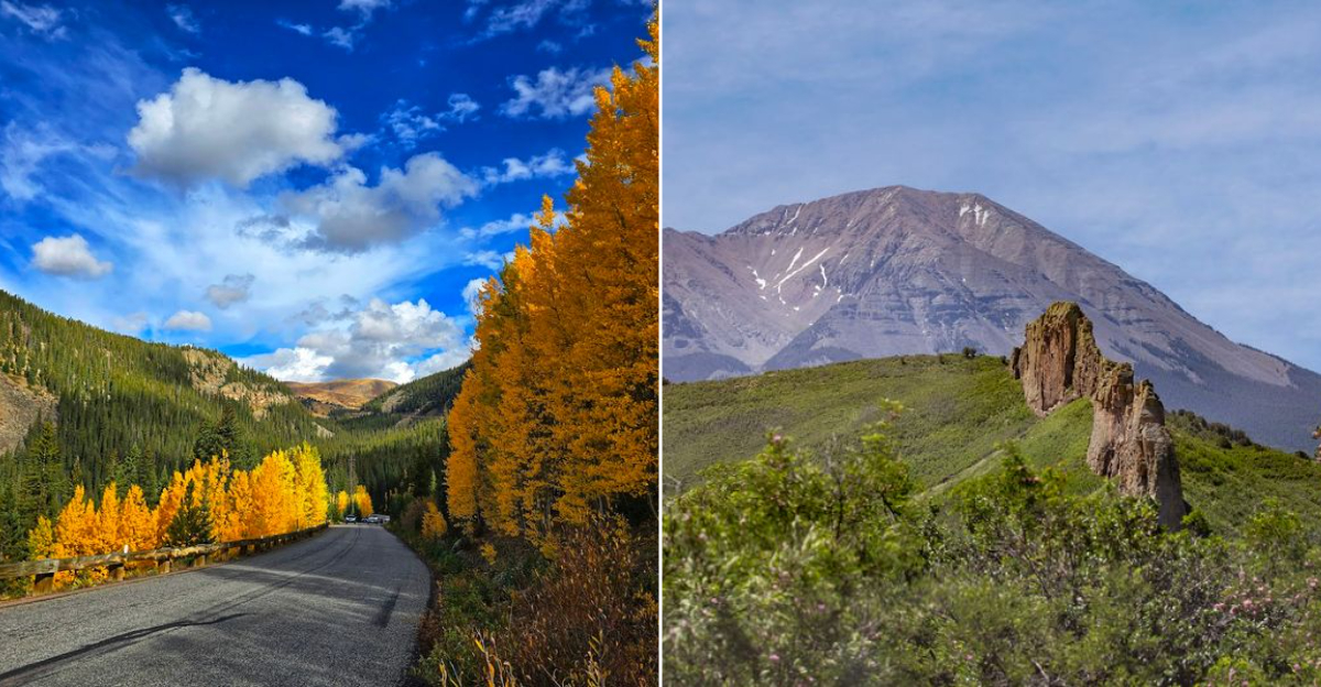
5. Highway of Legends: Trinidad, Cuchara, La Veta, and Walsenburg

The Spanish Peaks have been a landmark for travelers on the Santa Fe Trail for centuries, and the Highway of Legends gives modern road trippers the best possible front-row seat. This 82-mile National Scenic Byway runs from Trinidad through Cuchara and La Veta up to Walsenburg, threading through a landscape that layers volcanic geology, Hispanic heritage, and southern Colorado’s unhurried rural character into something genuinely unforgettable.
The volcanic dikes radiating out from the Spanish Peaks are the geological showstopper. These long, jagged rock walls jut straight out of the meadows like the fins of some buried prehistoric creature, and they appear suddenly enough to make you brake and stare.
The small communities along the route, particularly La Veta, have an artsy, slightly offbeat personality that makes stopping feel rewarding rather than obligatory.
Note that the Cordova Pass extension is gravel and closes in winter, so stick to the paved main route if you are traveling outside summer. Trinidad at the southern end is a historically rich town that deserves more attention than it typically gets.
The whole byway runs at lower elevations than most Colorado drives, making it a solid option when mountain passes are still snow-covered in spring.
6. Guanella Pass Scenic Byway: Georgetown to Grant

Georgetown is one of those Victorian silver-mining towns that Colorado does so well, all gingerbread trim and mountain backdrop. But the real reward starts when you leave town and begin climbing Guanella Pass on a byway that manages to pack an extraordinary amount of scenery into just 22 miles.
The road runs from Georgetown up and over the pass at 11,669 feet before descending to the small community of Grant near the South Platte River.
The middle section of the drive, up in the subalpine and tundra zones, is where things get genuinely spectacular. Willows turn brilliant gold in September, reflecting in the small ponds and streams that dot the valley floor.
Mount Bierstadt, one of Colorado’s more accessible fourteeners, looms at the top and draws hikers from the trailhead near the summit. The pass reopens around Memorial Day weekend and closes around late November, so summer and fall are your windows.
What I appreciate most about Guanella Pass is its scale. It feels intimate rather than overwhelming, manageable rather than intimidating.
You can drive it, hike a bit, eat a sandwich on a rock, and be back in Denver for dinner without any of the logistical stress that bigger drives tend to generate.
7. Grand Mesa Scenic Byway: Mesa to Cedaredge

Grand Mesa is the world’s largest flat-top mountain, a geological oddity that rises more than 10,000 feet above sea level and holds over 300 lakes on its broad summit plateau. The Grand Mesa Scenic Byway climbs from the town of Mesa on the north side up through aspen and spruce forest before descending to Cedaredge on the south, covering about 55 miles of road that most Colorado visitors completely overlook.
That oversight is a genuine gift to those who find it. The summit plateau feels like a different Colorado entirely, quiet and lake-studded and blessedly uncrowded even in peak summer.
Fishing is excellent, the camping is peaceful, and the views north toward the Book Cliffs and south toward the Uncompahgre Plateau are the kind that make you feel like you have discovered something secret.
Services between Cedaredge and Mesa are limited, so fuel up and carry water before you start climbing. The byway is designated as a National Scenic Byway, which means it meets a high bar for natural and recreational significance.
Fall color here is underrated, arriving in waves as the aspens peak at different elevations across the plateau. Grand Junction is close enough to serve as a comfortable base for the day.
8. Silver Thread Scenic Byway: South Fork, Creede, Lake City, Blue Mesa Reservoir

There is a stretch of the Silver Thread Scenic Byway near Creede where the Rio Grande squeezes through a narrow canyon so tight that the road, the river, and the canyon walls all seem to be competing for the same few feet of space. It is one of the most dramatic canyon passages in the state, and it arrives almost without warning, which makes it twice as thrilling.
The full byway runs about 75 miles from South Fork through Creede and Lake City to the Blue Mesa Reservoir area, following the upper Rio Grande through terrain that shifts constantly between open meadow, tight canyon, and high mesa. Creede is a former silver-mining boomtown that now operates as a charming small community with a respected repertory theater and a main street that has kept its historic bones intact.
Lake City sits near the southern end and serves as a hub for jeep touring and backcountry exploration into the surrounding San Juan mountains. Blue Mesa Reservoir, Colorado’s largest body of water, provides a grand finale with wide water views that feel almost coastal in their expansiveness.
This byway rewards slow travelers who stop often and rush nowhere.
9. Top of the Rockies Scenic Byway: Leadville, Twin Lakes, Minturn, Copper Mountain

Leadville sits at 10,152 feet, making it the highest incorporated city in the United States, and the Top of the Rockies Scenic Byway uses that already-elevated starting point to climb even higher. The route connects Leadville, Twin Lakes, Minturn, and Copper Mountain through a series of mountain corridors that include Independence Pass, one of the most celebrated high-mountain road experiences in the entire country.
Independence Pass opened for the 2026 season with vehicle-length restrictions in place, so check those before you load up the trailer. At the top of the pass, the road crests at 12,095 feet and offers a short walk to a summit viewpoint that puts you eye-level with the Continental Divide.
Twin Lakes below the pass are a glacial pair of reservoirs backed by the massive bulk of Mount Elbert, Colorado’s highest peak.
Minturn is a small town in the Eagle River valley with a food scene that wildly exceeds expectations for its size. Copper Mountain on the northern end of the loop is a ski resort community that transitions gracefully into a summer recreation hub.
The whole byway feels like Colorado showing off, which, given what it has to work with, is entirely justified.
10. Unaweep-Tabeguache Scenic Byway: Whitewater to Placerville

Unaweep Canyon is one of Colorado’s more quietly baffling geological puzzles. The canyon has two creeks flowing in opposite directions out of a single valley, a drainage pattern that suggests the canyon was once carved by the Colorado River before the river changed course entirely.
Driving through it on Highways 141 and 145 from Whitewater to Placerville, you can feel the strangeness of the place even if you cannot fully explain it.
The byway covers about 133 miles and passes through terrain that transitions from high desert canyon to the wine country of the North Fork Valley to the mountain town of Placerville near Telluride. That range of scenery in a single drive is unusual even by Colorado standards.
The canyon walls rise dramatically on both sides in the Unaweep section, giving the drive an almost enclosed, intimate quality before the landscape opens back up.
This is not a drive that gets crowded, which is part of its considerable appeal. Services are minimal along sections of the route, so treat it like a backcountry experience from a planning standpoint even though the road is paved.
A full tank, good snacks, and a downloaded offline map will serve you well from Whitewater all the way to Placerville.
11. Los Caminos Antiguos Scenic Byway: San Luis Valley and Great Sand Dunes Region

The San Luis Valley is the kind of landscape that recalibrates your sense of scale. Flat and wide enough to make the sky feel like a physical presence, it is ringed by mountains on every side and anchored at its northern edge by the Great Sand Dunes, a 750-foot-tall dune field that has absolutely no business existing in the middle of the Rocky Mountains.
Los Caminos Antiguos, meaning the ancient roads, traces the historic routes through this valley in a loop of roughly 130 miles.
The byway passes through communities with deep Hispanic and Indigenous roots, making it one of the more culturally layered drives in Colorado. San Luis, the oldest continuously occupied town in the state, sits along the route and rewards a short stop.
The Stations of the Cross shrine above town is an unexpected and moving piece of outdoor art that many visitors discover entirely by accident.
Great Sand Dunes National Park is the obvious centerpiece, and it earns the attention. Medano Creek runs along the base of the dunes seasonally, creating a surreal beach experience at 8,000 feet.
Plan to arrive early in the morning when the light is low and the sand is still cool enough to walk on comfortably.
12. Cache la Poudre-North Park Scenic Byway: Fort Collins to Walden

Fort Collins is well-known for its craft beer scene and Colorado State University energy, but fewer people realize it is also the starting point of one of Colorado’s most underappreciated scenic byways. The Cache la Poudre-North Park Scenic Byway follows the Poudre River west from Fort Collins through a dramatic river canyon before climbing over Cameron Pass and descending into the wide, quiet grasslands of North Park near Walden.
The canyon section is the kind of scenery that makes drivers slow down instinctively. The Poudre is Colorado’s only designated Wild and Scenic River, and the canyon it has carved is narrow, sheer-walled, and genuinely beautiful.
Kayakers and fly fishermen share the corridor with road trippers, giving the whole stretch a lively, purposeful energy that feels alive rather than merely scenic.
CDOT notes heavy summer traffic and livestock crossings on this byway, so patience is part of the experience. North Park on the other side of Cameron Pass is moose country, and sightings along the willowy creek bottoms are common enough that stopping to scan the treelines becomes a reflex.
Walden is a small ranching town with a straightforward, no-nonsense character that makes it a satisfying destination rather than just a turnaround point.
13. Colorado River Headwaters Scenic Byway: Grand Lake to State Bridge

Most people meet the Colorado River at the Grand Canyon, when it is already enormous and world-famous. This byway lets you meet it young.
Starting at Grand Lake, where the river begins its long journey southwest, the Colorado River Headwaters Scenic Byway follows the river for roughly 80 miles through Granby, Hot Sulphur Springs, Kremmling, and down to State Bridge, watching the river grow from a modest mountain stream into something with real authority.
The stretch from Kremmling to State Bridge includes gravel sections and limited services, so this is not a drive for the unprepared. But those who come ready with a full tank and offline navigation are rewarded with canyon scenery along the lower Colorado that few tourists ever see.
The contrast between the wide, open Granby basin and the tighter canyon country downstream is one of the drive’s most satisfying progressions.
Hot Sulphur Springs is a small town worth a stop for its historic hot springs resort, which has been soaking tired travelers since the 1800s. State Bridge at the southern end is a quirky outdoor music and camping destination with a loyal following.
The whole byway has a raw, unpolished quality that feels refreshingly honest compared to more heavily promoted Colorado drives.