This Fascinating Arizona Hiking Trail Leads Straight To Ancient Petroglyphs
The desert can be a tough crowd, but Arizona always knows how to put on a show that leaves you laughing, gasping, and questioning whether you’ve accidentally walked onto a movie set.
I set out with nothing but a water bottle, a vague sense of curiosity, and a pocketful of trail snacks that soon turned into makeshift bargaining chips for the curious critters I met along the way.
The path twisted through red‑rock corridors like a backstage hallway, and just when I thought I’d reached the end of the performance, the rocks burst into a silent chorus of ancient carvings.
It felt as if the desert itself had staged a surprise art installation, and I was the unsuspecting audience. Minus the popcorn, but plus a whole lot of awe.
Where The Maze Rock Art Site Actually Is

In the wide open stretch of House Rock Valley in northern Arizona, the Maze Rock Art Site sits within Vermilion Cliffs National Monument, managed by the Bureau of Land Management.
The site is located roughly one mile from the Utah state line, placing it in one of the most remote and visually dramatic corners of the American Southwest. To get there, you follow House Rock Valley Road, an unpaved route that branches off US 89.
The trailhead is about 10.8 miles south of US 89, or 18.7 miles from US 89A, marked by a BLM sign that is easy to spot once you know to look for it. Parking is a simple pull-out on the west side of the road, directly across from where the trail begins.
The road can get rough and slippery when wet, so checking the weather forecast before heading out is a smart move. During dry conditions, most standard 2WD vehicles handle the road without any trouble.
The Hike : Short, Sweet, And Surprisingly Rewarding

For anyone who has ever skipped a trail because it sounded too strenuous, this one is a pleasant surprise. The round-trip distance ranges between 0.7 and 1.5 miles depending on your exact path, and the elevation gain is only about 150 to 200 feet.
Most visitors complete the hike in 30 minutes to one hour, making it accessible for families, older hikers, and casual explorers alike.
The trail starts with a gentle uphill climb, then moves through a few short switchbacks before opening up onto a flat stretch across a sagebrush basin. That open section feels almost meditative, with the silence of the high desert surrounding you and the red cliffs growing larger with every step.
Near the end, a fence with a metal gate marks the boundary of the petroglyph area.
The final ascent to the rock art is brief but meaningful, building just enough anticipation before the carvings come into view. First-timers often say the site feels more impressive in person than any photo suggests.
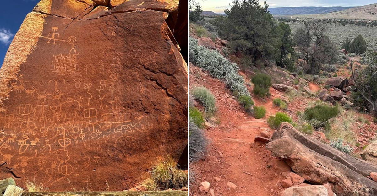
The Petroglyphs That Give This Place Its Name

The star of the show is the maze petroglyph itself, an intricate, swirling design carved directly into the red Moenave Formation cliff face. It is the kind of image that draws your eyes in and keeps them moving, following the lines inward and outward like a puzzle that has no wrong answer.
Scholars believe carvings like this carried ceremonial or symbolic meaning for the people who made them. The Ancestral Puebloan people, sometimes called the Anasazi, created these carvings between roughly 850 A.D. and 1300 A.D.
That means the oldest marks here are over 1,100 years old and still holding strong against the desert air. The maze design is so detailed and well-executed that it genuinely makes you wonder what tools and techniques the artists used.
Standing in front of it, you get a real sense of how much intention went into the work. This was not casual scratching on a rock; it was deliberate, skilled, and clearly meaningful to the community that created it.
Other Carvings Worth Looking For At The Site

The maze gets the most attention, but the surrounding rock surfaces are filled with other carvings that are equally captivating. One of the most talked-about images is a two-headed snake with a spiral tail, often shown curling next to a centipede and human figures.
The combination is visually striking and has sparked plenty of debate among researchers about its ceremonial significance. Bighorn sheep appear across several panels, their horns curving in that classic stylized way that shows up in Ancestral Puebloan rock art across the Southwest.
You will also spot deer, mountain lions, and geometric shapes that repeat in patterns suggesting ritual or calendrical meaning. Human-like figures, sometimes called anthropomorphs, appear in dynamic poses that suggest movement or ceremony.
One practical tip: take your time moving along the cliff face and boulders rather than just stopping at the first panel you see. Some of the smaller, quieter carvings tucked into corners turn out to be the most personal and moving pieces of the entire collection.
Why This Site Is Remarkably Well-Preserved

Rock art sites across the American Southwest have suffered badly from vandalism, weathering, and neglect over the decades. The Maze Rock Art Site stands out because it has largely escaped that fate, remaining one of the cleanest and most intact petroglyph locations in Arizona.
There is no visible graffiti, and the carvings retain a sharpness that allows visitors to appreciate the original artistry without squinting or guessing. Part of the credit goes to the site’s remote location.
Because it requires a drive on an unpaved road and a short hike, casual passersby do not stumble across it accidentally.
The BLM has also installed fencing around the main petroglyph area, along with informational notices that remind visitors to respect the site and follow Leave No Trace principles.
Visitors are asked not to touch the carvings, as even the oils from human skin can cause gradual damage over time. Keeping a respectful distance and using zoom on your camera is the best way to appreciate the art while helping it last another thousand years.
The Best Time Of Year To Make The Trip

Timing matters a lot when visiting a site in the high desert of northern Arizona. The Maze Rock Art Site faces west, which means it sits in shade during the morning hours and receives direct sun in the afternoon.
That makes an early morning start ideal for both comfortable temperatures and better lighting conditions for photography.
Spring and fall are the sweet spots for this visit. Temperatures are mild, the light is golden and flattering, and the surrounding landscape looks its most vivid.
Summer visits are possible but demand serious preparation, including extra water, sun protection, and an early departure time to beat the midday heat that can climb well above 100 degrees Fahrenheit in this part of Arizona.
Winter visits can be beautiful on clear days, with the red cliffs glowing against a cold blue sky, but House Rock Valley Road can become impassable after rain or snow. Checking road conditions through the BLM website before any visit, regardless of season, is a habit worth forming.
Nearby Attractions

House Rock Valley Road is not a one-trick road. The same stretch of unpaved highway that leads to the Maze Rock Art Site also provides access to some of the most iconic landscapes in the American Southwest, making it worth planning a full day or even a multi-day trip around the area.
The Wave, one of the most photographed sandstone formations in the world, sits nearby but requires a lottery permit to visit. Wire Pass trailhead, the entry point to the stunning Buckskin Gulch slot canyon, is also accessible from this road.
White Pocket, another visually extraordinary rock formation, draws photographers from around the world. And the Condor Viewing Area along House Rock Valley Road offers a real chance to spot California condors soaring overhead, one of the rarest birds in North America.
Combining the Maze Rock Art Site with one or two of these nearby stops turns a simple hike into a genuinely epic day in the desert, the kind of adventure that fills a full memory card and earns serious bragging rights back home.
Practical Tips For First-Time Visitors To The Maze

A little preparation goes a long way at a remote site like this one. Start by downloading an offline map before you leave cell service behind, because signal is unreliable along House Rock Valley Road.
The BLM trailhead sign is helpful, but having a GPS coordinate saved on your phone, specifically 36.9293 N, 111.9107 W, removes any guesswork about where to park and start walking. Bring at least one liter of water per person even for this short hike, especially between April and October.
Sturdy trail shoes with good grip handle the rocky terrain much better than sandals or flat-soled sneakers. A hat and sunscreen are non-negotiable in the open sagebrush section of the trail where shade disappears completely.
Binoculars are a surprisingly useful tool at this site, letting you study smaller carvings on higher sections of the cliff without getting dangerously close to the rock face.
A field notebook for sketching or journaling also adds something special to the experience, turning a short hike into a personal record of one of Arizona’s most intriguing ancient places.